Using tree rings to date past earthquakes
University of Canterbury PhD student, Sophie Newsham, is using ancient trees to help date past earthquakes on the Alpine Fault.
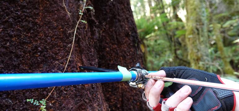
Trees grow a new ring every year, but extreme events – like earthquakes, fires and floods – can visibility disrupt that growth. Strong shaking can break branches, snap roots or change soil conditions – all things that stunt growth and show up in the tree’s rings as abnormal growth patterns.
Used alongside other geological evidence, trees can help scientists more accurately determine the age of prehistoric earthquakes.
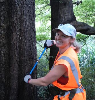 Sophie is applying this technique to trees along the Alpine Fault, on the west coast of the South Island. The Fault is one of New Zealand’s biggest seismic hazards, with a 75% chance of generating a large earthquake (Mw 8 or larger) in the next 50 years.
The last major Alpine Fault earthquake is thought to have happened 300 years ago, but a more precise estimate could help reduce uncertainty in seismic hazard models used for land‑use planning and risk management across New Zealand.
Sophie’s research is part of a University Research Programme funded by NHC Toka Tū Ake and led by Prof Andy Nicol. The programme uses evidence from past earthquakes to improve understanding of future hazard and risk.
For our latest Researcher Profile series, we spoke to Sophie about her NHC Toka Tū Ake-funded work.
What’s your NHC Toka Tū Ake-funded project in a nutshell, and why is it important to New Zealand?
The aim of my NHC funded project is to date Alpine Fault earthquakes using tree-rings. I have compiled and reanalysed all available evidence for Alpine Fault earthquake ages over the past 500 years and an now adding new tree‑ring data to refine these earthquake timings.
I use tree ring data from forests near the fault to identify when past earthquakes occurred and how those events affected the landscape. Trees can record prehistoric earthquakes in their growth patterns, and when the timing of those signals is combined with existing geological and paleoseismic evidence, we can build a more precise picture of Alpine Fault earthquakes.
This matters because the Alpine Fault is one of New Zealand’s highest‑impact seismic hazards and improving our understanding of its recent earthquake behaviour helps strengthen hazard models, planning, and community preparedness in the future.
What’s your favourite part of being a researcher?
My favourite part of being a researcher is getting out into the field. Exercising and spending time in the outdoors and connecting with the environment while collecting the tree-ring data is the best part for me.
I also love the interdisciplinary nature of my work. Studying past earthquakes through tree rings means collaborating with ecologists, forestry experts, and earthquake scientists, each bringing a different way of seeing the same problem.
That blend of fieldwork and teamwork keeps the research exciting, grounded, and full of new ideas.
How is your research helping make New Zealand more resilient to natural hazards?
My research helps improve New Zealand’s resilience by building a clearer, more detailed picture of how the Alpine Fault has behaved over the past 500 years. Tree rings can record sudden environmental changes caused by strong shaking or ground deformation, and when combined across many sites, they form a high-resolution timeline of past Alpine Fault earthquakes.
 By refining the timing and impacts of past earthquakes, my work supports more accurate forecasting of future Alpine Fault earthquakes. This information helps scientists, emergency managers, and communities understand what kinds of shaking, damage, and environmental effects we may need to prepare for.
Ultimately, the better we understand the Alpine Fault's past behaviour, the better we can plan for what comes next. This can improve the readiness, response planning, and long term resilience for people who live, work, and travel across Te Wai Pounamu, South Island.
What sparked your interest in studying natural hazards?
I’ve always loved learning how the natural environment works, and I’m someone who instinctively asks a lot of questions about the landscapes around me. That curiosity drew me toward studying geology and disaster risk, and resilience.
My interest in natural hazards also comes from wanting to help and protect people, potentially influenced by my years as a rafting guide. Guiding taught me how safety and the natural-world are closely connected. Studying natural hazards felt like the perfect way to combine my curiosity with that drive to support people and communities.
What are your ambitions for further research or careers after your studies?
After my PhD, I hope to continue developing and applying tree ring science to understand past earthquakes, not just along the Alpine Fault, but across New Zealand and internationally. Tree rings offer a precise way to date prehistoric earthquakes, and I’d love to see this approach used more widely to fill gaps in fault histories.
Whether I stay in research or move into a hazard-focused organisation, my goal is the same: to strengthen our resilience to natural hazards.
What’s a common misconception in your field that you want to clear up?
A common misconception is that we know the exact year of the most recent Alpine Fault earthquake (being 1717 CE) and can use it casually or confidently without considering the uncertainties behind the data.
In reality, even with excellent evidence, prehistoric earthquakes are reconstructed from natural records such as tree rings, and radiocarbon dating of lake sediments, each with its own range of uncertainty.
When people quote the “last Alpine Fault earthquake” as if it is an exact and indisputable year, that oversimplifies a complex set of evidence and can give a false sense of precision. Tree rings can provide yearly precision for past earthquakes, but only with a large, widespread, annually resolved sample set.
Understanding how we know prehistoric earthquake ages and the uncertainties involved is crucial for good science communication and responsible hazard planning. Clear communication about uncertainty makes our forecasts more robust and helps avoid misleading claims about earthquake cycles or “overdue” events.
Do you have a favourite memory related to your research?
One of my favourite memories is from one of our field campaigns, when a small team of us spent 10 days camping in the Cascade Valley in South Westland.
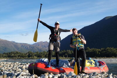 We spent each day coring trees in dense beech forest along the Alpine Fault, surrounded by the tall, red Olivine Range. Living simply beside the river made the work feel both focused and special. When it was time to leave, we loaded all our gear into a raft and paddled down the Cascade River back to the vehicle.
This was an unforgettable way to finish an incredible stretch of fieldwork and a reminder of why I love this work so much.