Researcher takes closer look at how earthquakes shift rivers
Earthquakes can move rivers and cause flooding – so how do we prepare? Researcher Erin McEwan's latest work gives us some answers.
Flooding is one of the most under-researched hazards associated with earthquakes.
Co-seismic River Response (CRR) refers to how rivers react immediately or shortly after an earthquake, through changes in flow behaviour, channel course, and flood pattern.
CRR can reshape landscapes, damage infrastructure and alter ecosystems. Given New Zealand’s abundance of both rivers and fault lines, it’s a significant hazard here – as witnessed in the Kaikōura, Christchurch, and 1987 Edgecombe earthquakes, all of which increased flood risk for surrounding communities.
So, it’s a wonder that it hasn’t been well researched until Erin McEwan took a closer look as part of her PhD.
Through combining traditional flood modelling techniques with knowledge of where fault lines are and how they might rupture, Erin’s research provides a method to simulate near-fault instances of CRR, giving communities an early warning of how an earthquake may cause a major change in local flood hazard.
Erin recently completed her PhD and is about to start a new job in natural hazards risk reduction. Before her first day of work, Erin took some time to talk to us about her research as part of our NHC Researcher Profile series.
What do you like most about your work?
From the outset, I knew that I wanted to conduct research that strengthens our understanding of New Zealand’s natural hazard landscape.
I quickly found that while long-term fault–river interactions are well studied, little exists quantifying how surface ruptures beneath rivers can immediately alter local flood hazard. Yet global case studies show CRR events can severely impact local populations and disrupt flood protection infrastructure. This revealed a critical research gap, especially for seismically active regions across New Zealand.
I value that my research is helping to address this gap and contributes to making communities more aware of earthquake multi-hazards and their impacts.
Why is it important to invest in natural hazards research like yours?
Applying my CRR methodology in Otago’s Taieri Basin, where the Titri fault underlies the Taieri River and nearby flood protection levees, shows that even an average single-event displacement could compromise the protection offered by the Lower Taieri Flood Protection Scheme. This may place residents at risk and expose Dunedin International Airport to increased flood hazard.
Case studies like this demonstrate why it is vital to assess and invest in research like mine. The findings enable planners to proactively develop targeted mitigation strategies and inform land-use decisions, helping to improve resilience in seismically active, flood-prone regions across Aotearoa New Zealand.
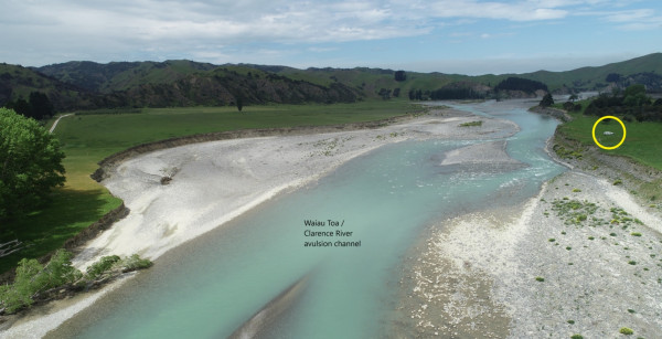
Drone aerial imagery taken 5 years following New Zealand’s 2016 Papatea fault rupture. Credit: Regine Morgenstern of Earth Science New Zealand (previously GNS).
What is your personal experience with natural hazards, and how has it influenced your research?
I lived through the Canterbury earthquake sequence and witnessed firsthand how the impacts of a major disaster can ripple through communities for years.
That experience was a key reason I chose to return to study. At the time, I realised how little I understood about the processes behind earthquakes.
While I expected ground shaking, I was completely surprised by other effects, such as liquefaction, permanent ground deformation, and changes in flood hazard. I remember feeling unprepared, having never considered how a major earthquake could influence almost every aspect of my life, including where I could live and work.
That gap in understanding motivated me to learn more and ultimately to pursue research aimed at improving awareness of and preparedness for earthquake-related multi-hazards in New Zealand.
What are your ambitions for your research or career?
My ambition is to continue producing research that directly informs natural hazard planning and risk reduction in Aotearoa New Zealand. I want to help bridge the gap between science and practice, by making hazard and risk data more usable for decision-makers, planners, and communities.
Longer term, I hope to contribute to shaping national policies around resilient infrastructure and land-use, particularly in areas exposed to compound or cascading hazard risks. Whether through research, collaboration, or applied work, my goal is to support safer, more prepared communities.
What does a resilient New Zealand look like to you?
My vision for a resilient New Zealand begins at the policy and planning level. As we face an increasing frequency of natural hazard events, it's essential that new development is approached proactively, with risk reduction embedded from the outset.
I’m also a strong supporter of public education campaigns like AF8, which empower people with the knowledge they need to respond effectively. In my view, a resilient community is one that understands the hazards it faces and is well prepared to protect lives, livelihoods, and critical assets.
We may not be able to stop natural hazards from occurring, but we can ensure our communities are equipped to withstand and recover from them.
Do you have a favourite anecdote or memory related to your research?
A recent highlight was when a council representative contacted me to say that they are increasingly fielding questions from West Coast farmers, who are concerned about how the rivers on their land, and associated flood protection structures, might respond during or after an Alpine fault rupture.
Local teams are now exploring ways to help answer that question. It was a really heartening moment. It showed that my research is reaching the people who need it, and is beginning to inform practical efforts to increase earthquake preparedness and reduce risk. That is exactly the kind of impact I hope for.