Earthquakes can shift rivers and break flood defences – but new research can help communities prepare
New research is helping reveal how earthquakes can change the course of rivers, damage stop banks and increase the risk of flooding – and where in New Zealand this is most likely to happen.
Te Whare Wānanga o Waitaha University of Canterbury (UC) PhD student Erin McEwan has created the world’s first database showing how earthquakes have affected rivers and flood protection in the past. She hopes the work will help emergency planners and councils better prepare for future disaster.
“This is a hazard that hasn’t had much attention before,” says McEwan. “But in New Zealand, where we have thousands of rivers and lots of active fault lines, it’s inevitable that they will intersect and interact.”
Over 3,700 rivers in New Zealand could be at risk of earthquake-related flooding if the fault lines beneath them rupture. More than 450 of these rivers are the size of, or larger than, Canterbury’s 35-kilometre-long Hororata River.
McEwan’s research shows that earthquakes can cause rivers to shift, flood, or get blocked entirely – sometimes creating permanent dams and lakes. This can lead to serious flooding, not just during the earthquake but for months or years afterwards.
The 1987 Edgecumbe earthquake is one example. It caused major damage to stop banks and dropped parts of the land into the floodplain of the Rangitaiki River. The area has experienced several damaging floods since, including a major flood in 2017 that forced 3,000 people to evacuate.
Other major quakes, like those in Christchurch and Kaikōura, also changed how water moves across the land, redrawing flood maps and putting new areas at risk.
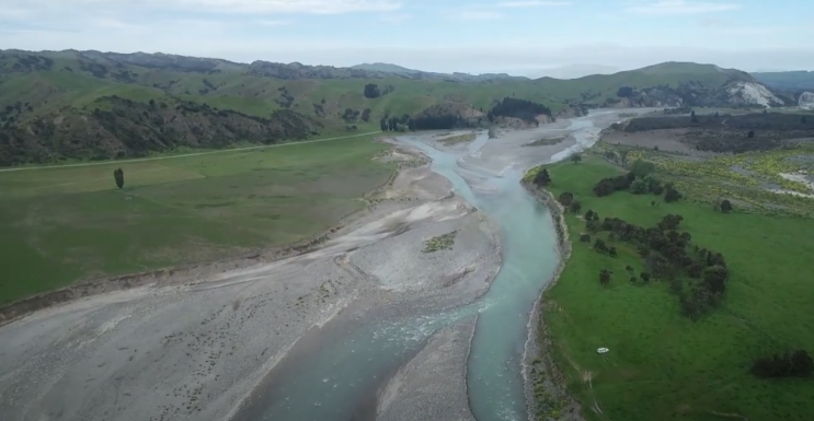
A stillshot of a drone video showing the Clarence River Avulsion, captured five years following the 2016 Kaikōura earthquake. Drone footage credit: Regine Morgenstern, ESNZ (2021).
“It’s a very real hazard that we see again and again after large earthquakes,” says McEwan. “This research gives us tools to start predicting where those risks might be highest.”
To build her model, McEwan and her team studied 52 earthquakes around the world where rivers were affected by fault ruptures. They combined this global data with New Zealand’s fault maps and existing flood modelling techniques to test future scenarios.
“If this method was used across New Zealand, it could help communities prepare more earthquake-resilient flood risk mitigation,” says McEwan.
She acknowledges it can be unsettling to think about earthquakes undoing years of flood protection work, but says planning ahead is key.
“We can’t stop earthquakes or floods — but we can help people be ready for them,” she says.
“My goal is to get this into the hands of councils and planners so they can run their own ‘what if’ scenarios and make smart decisions for their communities.”
Placing homes and important infrastructure on or near active fault lines and flood zones is risky, and McEwan’s research could help show how those risks might increase after an earthquake and where it might be safer to build in future.
McEwan’s work was supported by a Natural Hazards Commission Toka Tū Ake (NHC) research grant awarded to her UC supervisor, Dr Timothy Stahl, to study earthquake-related hazards.
Dr Natalie Balfour, Head of Research at NHC says, “Damage from earthquakes isn’t just caused by shaking, which is why research that looks at the suite of related hazards is so important – it helps us understand the full picture of earthquake risk and gives decision-makers the science they need to plan ahead.
“From a planning perspective, knowing where flooding is more likely after a quake gives us a powerful new tool to protect people and properties.”
Find out more:
Erin's full paper – Seismic hazard and shifting channels: Exploring coseismic river response(external link)
Dr Timothy Stahl – University of Canterbury website(external link)